Green Luminaries light the way

GL_screencap.png

Milwaukee Metropolitan Sewerage District’s (MMSD) Green Luminary awards highlight exceptional projects using green infrastructure to collect and harvest rainwater within the MMSD service area, improving water quality in our rivers and lake.

The Green Luminary award is given to businesses, organizations, and communities that not only invest in green infrastructure to clean our water, but also inspire us through education and engagement.

We invite you to explore the newly updated Green Luminaries water story through the Milwaukee Community Map, where over 40 project videos showcase a wide variety of green infrastructure designs across various scales.

The Kaufmann house transformed the exterior of their property with green roofs, porous pavement, bioswales, and rain gardens. The residential project highlights the environmental benefits of managing rainwater where it falls. The Kaufmann house also serves as an inspiration to other community members in converting components on their own home to better serve the environment while beautifying their yard.

Poblocki Paving converted a parking lot into porous pavement, collecting water in underground tanks that in turn is reused to supply water for their business. As a result, the paving company saves money, time, and gas--illustrating the business case for green infrastructure. Poblocki is a proud example of a for-profit company helping the local environment and directly benefiting from their green infrastructure.

The Urban Ecology Center, with three locations throughout the Milwaukee area, incorporates green roofs, rain gardens, and rain barrels at all of its campuses. All the water collected is kept on-site, used to irrigate gardens and flush toilets. Thousands of kids and adults visit the Urban Ecology Center annually, meaning that education about the value of green infrastructure reaches a diverse cross-section of Milwaukeeans.

-Catherine Trowbridge

Discover Fish Habitat Hotspots

In 2018, UW-Milwaukee School of Freshwater Sciences graduate student Brennan Dow worked with SFS professor Dr. John Janssen to survey the composition of underwater fish habitat in and around the Milwaukee harbor.

Dow used side-scan sonar from a boat he maneuvered throughout the entire Milwaukee Estuary—the lower reaches of the city’s three major rivers, the inner harbor, and the outer harbor. This mapped the depth and character of the bottom, providing an idea of the kinds of places that could be good habitat for different kinds of freshwater fish—which have different needs during different parts of their life cycles.

In some key spots, he also dove under the water to take a closer look at substrate, vegetation, and forage conditions.

Dow assembled all the data he collected into a technical map establishing the current baseline of fish habitat in the Milwaukee Estuary. That map is intended to guide and support efforts by the School of Freshwater Sciences and others to improve fish habitat while respecting the harbor’s modern identity as a functioning port.

Part of the project also intended to communicate this underwater story to the public.

School of Freshwater Sciences connected with Kim Beckmann, an art professor at the UW-Milwaukee Peck School of the Arts, who led the effort to create beautiful and contextually rich large-format illustrations of the various habitat hotspots explored. Those seven areas include details of the North Harbor Gap/Green Breakwall, Summerfest Lagoon, and South Shore in the outer harbor; Grand Trunk Inlet on the Kinnickinnic River; Burnham Canal and South Menomonee Canal on the Menomonee River; and the North Avenue Spawning Reef on the Milwaukee River.

Beckmann’s maps were guided by the expertise of Jeff Houghton, who took over Dow’s project when the latter went on to work for the Wisconsin Department of Natural Resources’ Office of Great Waters (Dow now heads up the state’s effort to improve the waters of the Milwaukee Estuary Area of Concern).

The work was such a success that in 2019, Houghton took on the task of surveying other harbors up and down Lake Michigan, using side-scan sonar and targeted scuba dives to create more habitat inventory maps.

The Milwaukee Estuary harbor habitat hotspots inventory was supported by the UW-Milwaukee School of Freshwater Sciences, Wisconsin Department of Natural Resources, Harbor District, Inc., and Fund for Lake Michigan.

The short video above shows an overview of Beckmann’s illustrated maps geolocated in Google Earth along with side-scan sonar imagery used to support Dow’s and Houghton’s technical maps. A visual primer of some of our local fish species features the impeccable illustrations of Virgil Beck.

Explore more by accessing the Milwaukee Community Map in Google Earth Pro on Desktop and opening the “Habitat Hotspots” Deeper Dive. Zoom in to see what kind of fish call each hotspot home, then click on them to learn more about each species’ preferred vegetation, forage, and substrate.

Discover the Area of Concern

Today in Cleveland, Ohio, professional water advocates and managers from around the Great Lakes are gathering at the annual Area of Concern (AOC) conference. The Milwaukee Estuary is one of over 40 areas so designated due to historic industrial contamination that requires major cleanup efforts to make the water “swimmable and fishable” again.

Never heard of Milwaukee’s AOC? Check out the video overview above. Then explore the many types of projects—habitat, sediment, fish passage, and more—making a difference in the Milwaukee Community Map. Open the map in Google Earth Pro on Desktop, then select the “Fishable & Swimmable!” Deeper Dive and toggle through the many layers and click on the points of interest.

In other news, this weekend is the annual Maker Faire! This year’s free event, formerly held at State Fair Park, is downtown at the Wisconsin Center. Reflo will be there with our Virtual Water Table and the Milwaukee Community Map on a big screen. Join us for family-friendly fun for all!

Discover the Harbor District

We’re looking forward to Harbor Fest this Sunday, Sept. 8, and hope you can join the community for a fun day out. We’re particularly excited about seeing the new Harbor View Plaza at the east end of Greenfield Avenue—this promises a new public access point down to the water in the core of Milwaukee’s Harbor District.

Have you heard of the Harbor District? Have you read the Harbor District Water & Land Use Plan that is to guide redevelopment at the meeting of Milwaukee’s three rivers? Check out the video tour above for an overview of some of the transformations, plus the vision for the future of this dynamic area.

Then explore more at the Milwaukee Community Map in Google Earth Pro on Desktop. Toggle on the “Harbor District” Deeper Dive and check out areas that the Water & Land Use Plan call for adding parks, riverwalks, and bike ways. Imagine what the former Solvay Coke parcel could look like after Komatsu’s headquarters relocate to this keystone property.

Discover Historic Waterways

2019-08-28--Historic Waterways.jpg

Before Wisconsin became a state in 1848, it was territory mapped by federal land surveyors preparing for public land sales. Surveying the land into a grid of square townships and subdivided plots encouraged speculation, settlement, and development following widespread displacement of Native Americans. The Milwaukee area was initially surveyed in 1835, with more work in 1836 and 1837. (Ever notice how there are major arterial streets roughly every mile apart? This is a legacy of the surveyors’ gridlines.)

The maps and field notes from these surveys provide invaluable historical context about Milwaukee’s geography, hydrology, and ecology prior to urban development. Thanks to the mapping team at MMSD, who adapted a digital layer from the maps held by the Wisconsin Commissioner of Public Lands, you can now explore where surveyors noted historic waterways in our area. You’ll notice many more tributaries into the three major rivers, as well as areas denoted as wetlands, marsh, or swamp. Over time many of these areas were filled with land and many of the river channels straightened.

Access the Milwaukee Community Map in Google Earth Pro on Desktop, then toggle on the Basemaps section and fill in the circle by “Historic Water Maps.” There are two layers. The first is from the 1830s federal land surveys described above. The second is from roughly 60 years later based on USGS surveys. Can you find where waterways used to be near your home or neighborhood?

Discover Historic Water Recreation

Have you been to one of our beaches along Lake Michigan yet this summer? Did you know that Bradford Beach, Lincoln Memorial Drive, Veterans Park, and the Summerfest Grounds were all constructed on what used to be lakebed? They were all filled in with land.

In the late 1800s and early 1900s, before Milwaukeeans went down to our lakefront beaches in droves, they congregated in and along the Milwaukee River upstream of the former North Avenue Dam. Check out the video overview above to see where there used to be swimming schools along the river’s banks.

To explore more, access the Milwaukee Community Map in Google Earth Pro on Desktop. Toggle on the "Historic Water Recreation” Deeper Dive, then click on the features of interest to learn more. There are also nifty place-based links to video segments of A City Built on Water, the film by John Gurda and Claudia Looze.

Discover Swimming Pools & Pads

2019-08-14--Swimming Pools & Pads.jpg

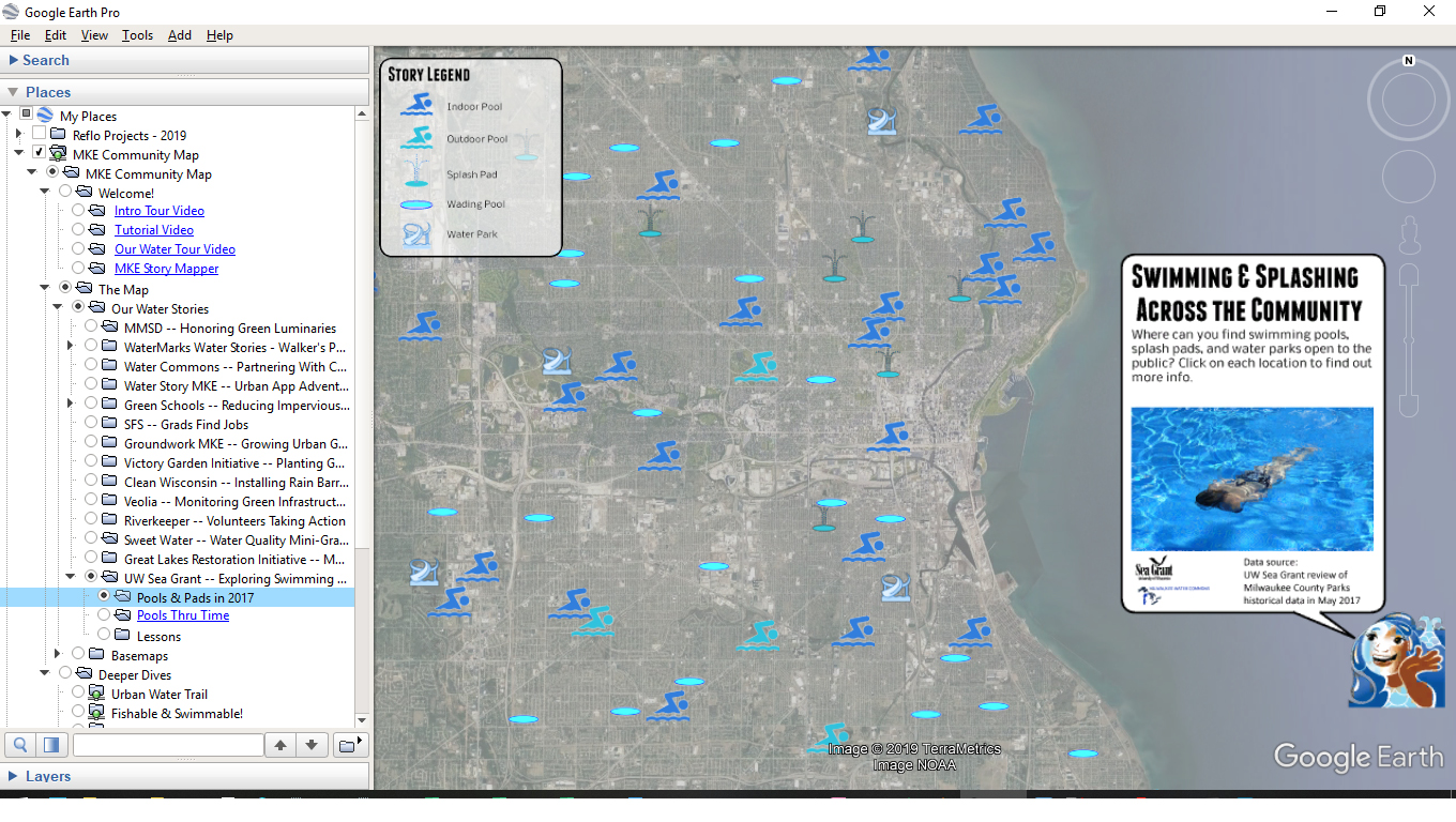
Summer is the best time for swimming in Milwaukee—it’s hot outside and fun to splash around with friends in cool water. Do you know the public swimming pool closest to you? Is your family aware of the many splash pads and wading pools across Milwaukee County? Have you been to one of own water parks at the Lincoln Park, Hoyt Park, Greenfield Park, or Kozy?

Check out the pools and pads in your neighborhood by accessing the Milwaukee Community Map. Open the map in Google Earth Pro on Desktop, then fill in the circle by “UW Sea Grant — Exploring Swimming Access” under the Our Water Stories section. Click on each icon for more details about indoor and outdoor pools, splash pads and wading pools, and water parks.

Discover the Urban Water Trail

The second annual Cream City Classic swimming race is scheduled for this Saturday, Aug. 10. If the weather holds, it should be an amazing morning to watch swimmers pulse through the Milwaukee River!

Due to improvements in water quality in recent years, Milwaukee’s waterways are witnessing a renaissance as an entertainment and recreation destination—swimming, boating, beachgoing, fishing, and more! Check out all the places you can access the water by exploring the Urban Water Trail courtesy of our friends at Milwaukee Riverkeeper.

The video above provides an overview. To explore more, access the Milwaukee Community Map in Google Earth Pro on Desktop, then toggle on the “Deeper Dive” labeled “Urban Water Trail.” Toggle through features organized by area or amenities, and check out suggested paddling day trips right in the City of Milwaukee! Just double-click to zoom to each route.

Discover Jones Island History

This weekend is the annual Kaszube picnic on Jones Island at Milwaukee’s smallest park. Do you know the Kaszubes? Do you know the story of Jones Island? Are you curious why what is actually a peninsula is called an island?

Today Jones Island is home to an industrial port and sewage treatment plant, but it was once home to a vibrant fishing village where an immigrant community of Kaszubes filled the swampy land for fishing shanties, homes, saloons, and even a school. Learn more about the dramatic historic transformations along our freshwater coast by checking out the video above.

Explore more by accessing the Jones Island “Deeper Dive” by opening the Milwaukee Community Map in Google Earth Pro on Desktop. Fill in the circle button by “Jones Island” and then click the points of interest to explore different historic features in the interactive map.

Discover Our City of Neighborhoods

2019-07-24--City of Neighborhoods.jpg

Events like the Riverwest 24, German Fest, and all the summer festivals remind us that Milwaukee is a City of Neighborhoods with immigrant identities woven into the fabric of our culture. Do you know the stories of our neighborhoods? How did Pigsville get its name? Where was Milwaukee’s “Little Italy”? What does “Harambee” mean?

We collaborated with historian John Gurda and Historic Milwaukee, Inc. to create an interactive companion to the popular book Milwaukee: City of Neighborhoods. Check it out through the Milwaukee Community Map.

Once you have accessed the Milwaukee Community Map in Google Earth Pro on Desktop, find the “City of Neighborhoods” layer under the section called Basemaps. Fill in its circle to turn it on, then click on each neighborhood shape to see a preview paragraph on its story and each colorful poster created by Jan Kotowitz. You can toggle on/off “Our Water Stories” layers on top of this basemap to see which neighborhoods feature different water-related projects.

Discover Green Luminaries

2019-07-22--Green Luminaries.jpg

On this day nine years ago, intense rain led to flooding that claimed one young man's life and caused over $30 million in damage to Milwaukee County. Streets turned into rivers deep enough for canoes, over 4,000 homes flooded, and a sinkhole at Oakland and North avenues swallowed an SUV. Meterologist John Malan reported that over 6 inches of rain fell in just one hour! The damage from the July 22, 2010 storm, however, inspired many Milwaukeeans to invest in green infrastructure.

In our first post highlighting the many amazing things you can discover through the Milwaukee Community Map, we invite you to explore the public, private, and community folks that MMSD has highlighted as "Green Luminaries" for their projects including green infrastructure to absorb stormwater where it falls. Check out the Milwaukee Community Map here!

Once you have accessed the Milwaukee Community Map in Google Earth Pro on Desktop, find the “MMSD — Honoring Green Luminaries” story under Our Water Stories. Click on each heron icon to see one of MMSD’s 42 short videos highlighting these projects. Use the map to discover where these water leaders are and toggle on/off different basemaps to explore different relationships.